In this page, you will find informations and advices we can give, based on our experience
Zion National Park - Utah
What to do if you have little time : East viewpoints of the park ; Pa'rus Trail ; Canyon Overlook
Zion is a beautiful park, a paradise for hikers. And there's something for everyone: easy with Pa'rus trail, refreshing in the water at the Narrows, sporting and dizzy with Angels landing, less frequented with Kolob Canyon and finally stunning with The Subway.
In Zion, part of the hiking trailhead is accessible thanks to a system of free shuttles. Fortunately, because the park is frequented and the traffic can be complicated. The eastern part of Zion is only accessible by car and we can expect slower traffic, especially when approchaing the tunnel.
Tip : It's very hot in Zion, between 95° and 104°F in summer. Before any hike, be sure to carry enough water.
Like all national parks, a contribution is requested at the entrance to the park. It is $ 35 per vehicle for 7 days. If you have the "America the beautiful" pass, access is included.
We advise you to devote at least 4 days to the visit of Zion if you go to The Subway, 3 days otherwise.
Subway
To have the luck to hike the trek to the Subway, you must register 3 months in advance, to a draw (on the website of Zion NP) as the entrance is limited to 80 people per days.
The hike is 10 miles round trip. The descent is quite easy even if you have to find your way between the rocks. The beginning of the trail is flat for about 0,6 mile. Then it goes down very  steep. Once at the bottom of the canyon, it is up the river alternating between the trail and walking in water. It is 2:30 to get to the Subway. The return is more difficult and tiring, especially the ascent of the canyon which has a high elevation gain (about 426 feet over a
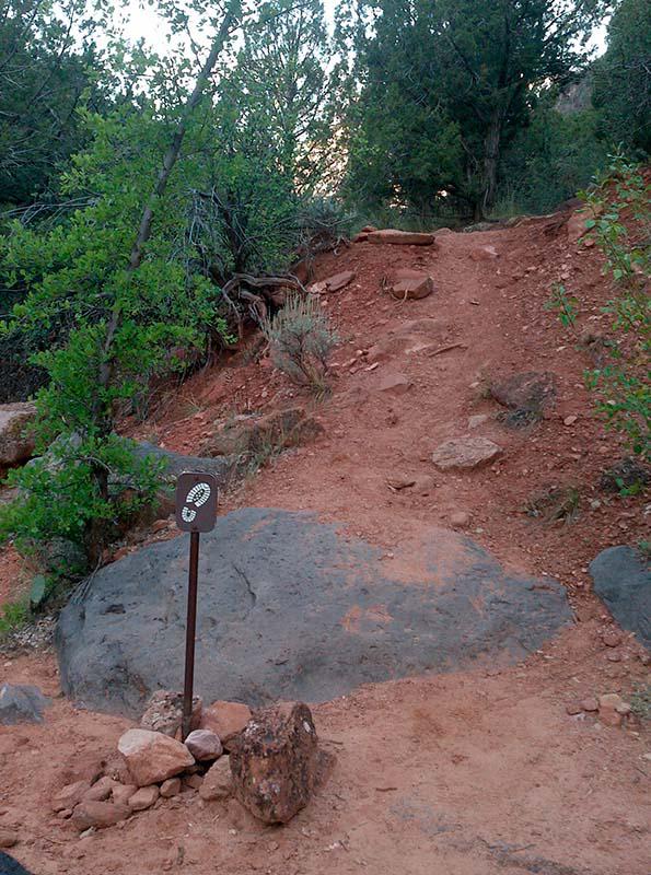
distance of 0,37 mile). Do not miss the way back up to the parking lot. It is indicated by two
signs : a footprint on one (see picture on left) and "Left Fork Trailhead" on the other. If you go too far, you will see yellow banner across the river, you will have to turn around.
Tip : start hiking early in the morning to enjoy cooler temperature. Do not hesitate to walk in the water as soon as possible to save time.
Photo tips : to have a good light in the tunnel, you have to be there before the sun illuminates the walls and bottom of the canyon. For example, during our trip in June 2012, we had to be there between 7:30 and 8:00 am to have enough time to settle cameras. From 9:15 am, too much light enters the canyon. By cons, for the pools we still can take pictures until about 10:30 am. Things are a little different in September. In general, the light is better, no matter the time of day. However, the best time to take pictures is from 1:30 to 2:30 pm. A tripod is mandatory for long exposure and the use of neutral density filters is recommended.
Access : from the city of Virgin, take Kolob Terrace Road to the parking "Left Fork Trailhead".
The Narrows
What a refreshing walk in the heat of Zion : The Narrows. Acces is via the Riverside Walk, paved path of 2 miles roundtrip, along the Virgin River. This walk is very easy and accessible to all. The rest is in the water of the Narrows, a narrow canyon with dizzying walls, as far as you want (returned by the same way).
Shuttle stop : Temple of Sinawava.
Tip : the stones are quite slippery, it is best to have a stick, but don't buy one because there are plenty at the beginning of the walk, let by previous hikers. Also provide neoprene booties to protect feet from cold. Before you start, remember to ask about the water level which can vary according the season. In 2010, we had some water to the buttocks.
Angel's Landing
![]()
 2,7 miles one way
![]() Half a day
Half a day
![]()
$30 per vehicle
Walk classified as "strenuous" on the brochure of the park. And it's justified ! The walk itself is not very long (6 miles roundtrip), but the denivelation is important : 1500 feet. For those who have vertigo or those who fear getting hurt, it is better to stop at Scout Lookout which already offers a breathtaking view of the canyon. The part from Scout Lookout to Angel's Landing is on a narrow rocky path with a vacuum on one side and a chain to hold on the other side. We chose to stop at Scout Lookout to avoid any risk of injury at the beginning of travel. Especially since we had to go down to the Subway the day after.
Shuttle stop : The Grotto
East Entrance
Between the East entrance of the park and the tunnel, several parking permit access to viewpoints. From these parkings, you can venture into much less crowded areas than the rest of the park. These ballads are however not marked and do not appear on the map of the park. We particularly recommend these walks because the scenery is beautiful and very different of the "free shuttles" accessible part of the park.
Separation Canyon
This is a wilderness hike not listed in Zion's guide. A hiking GPS is a useful aid because no path is traced and this place is very little frequented. Yet we see very beautiful landscapes. From the car park on Route 9, you must first go under the bridge and follow the wash. The walk is then in the sand and stones but it is not very long. At the N37°13'25.2" W112°53'49.7" GPS, turn left and climb the mountainside. It climbs quite steep. Then you have to continue south, sometimes steep, sometimes quiet, up to GPS N37°12'41.0" W112°53'51.5". You will then face Separation Peak, Nippletop Peak and Lonely Peak.
Access : The starting point of this hike is on Route 9 between the Mount Carmel Tunnel and the East Exit of Zion. Park on the roadside parking (GPS: N37°13'27.9" W112°53'36.1").
Observation Point & Hidden Canyon
The start of this long hike begins from the shuttle stop at Weeping Rock. It climbs all the time. The path passes through some of the narrows of Echo Canyon. Once arrived at the rim, it becomes flat to the final viewpoint. And here you have an impressive view of Zion including Angel's Landing. The climb to Observation Point is 4 miles with a vertical drop of 2150 feet.
On the descent, you can combine with Hidden Canyon. It rises a little more then it's quite fun with passages with chains because close to the void, steps, passages on tree trunks or under branches... There are some narrow passages but nothing more, then you arrive at an arch that is almost glued to the wall : Hidden Arch. A few meters away, a sign indicates the end of the trail. After it's a bit of climbing on big rocks.
The combined of these 2 hikes is about 9,3 miles round trip.
Shuttle stop : Weeping Rock
Canyon Overlook
Short hike of 1 mile round trip that leads to a nice viewpoint over Zion canyon. This hike is very busy.
Access : this is probably the most difficult part of this hike : find a place to park the car. You have to park at the car park at the eastern exit of the tunnel on route 9 that crosses the park.
Pa'rus Trail
![]()
 2,5 miles one way
![]() 1 to 2 hours
1 to 2 hours
![]()
$30 per vehicle
To join the Visitor Center the hike, of about 2,5 miles is fun because it's on the border of the Virgin River and it's very easy.
Shuttle stop : Canyon Junction.
Emerald Pools
![]()
 1,5 miles one way
![]() 1 to 2 hours
1 to 2 hours
![]()
$30 per vehicle
This hike is about 3 miles long. Quite fun, because under the trees, so it's pretty cool ! Pools can be out of water during summer. Viewpoints of the canyon are superb.
Shuttle stop : Zion Lodge.
Hoodoo City
This short hike which leads to a few hoodoos is 1,6 miles round trip.
Access : on the Kolob Terrace Road, park on the Hop Valley Trail parking lot. Then on foot, follow the Connector Trail East until you reach the road. Continue along the road for about 400 feet (parking available on a small parking lot at this level) and turn left on the trail that goes down. The suite is done on slickrock taking the direction of hoodoos.
Norhtgate Peaks Trail
Easy and pleasant hike under the pines, which leads to a beautiful view of peaks: Northgate Peak East and West and North Guardian Angel Peak. The round trip is 4 miles. This walk in the Kolob Terrace is much less crowded than the Zion Canyon.
Access : on the Kolob Terrace Road, park at the Wildcat Trailhead car park. Follow this trail for 0,9 mile and then turn right on the Northgate Peaks Trail for 1,1 mile.
Weeping Rock
![]()
 0,2 mile one way
![]() 15 to 30 minutes
15 to 30 minutes
![]()
$30 per vehicle
This short walk is only 0.4 mile but is steep. It allows to see an alcove in the rocks.
Shuttle stop : Weeping Rock.
Kolob Canyons
![]()
 3,1 miles one way
![]() 3 hours
3 hours
![]()
$30 per vehicle
Access to Kolob Canyons is via a second entrance to Zion NP. This part of the park is much less touristy than the part accessible from Springdale. You can see Double Arch Alcove (Middle Fork of Taylor Creek Trail 6 miles roundtrip) and pretty viewpoints of the Kolob Canyons Road.
Access : exit 40 on Interstate 15.
Deertrap Mountain
The beginning of the hike is under the pines and it is relatively flat with some parts of sand, some small climbs. Once out of the undergrowth, there is no more shade. The path passes through bushes and has no interest. You arrive at a first viewpoint, then continuing along the bank about 0,3 mile, you go to a second viewpoint. The view is superb.
Access : after leaving Zion from the East on Highway 9, turn left (North) on North Fork Road for 5.2 miles and turn left onto Pine Angle Road/Twin Knolls Road for 0,7 mile. Then turn left on Pine Angle Road for 160 feet then right on Buck Road for 0.6 mile. Turn left on Beaver Road for 233 feet and right on West Pine Street for 0.5 mile. Park on the parking lot or on the roadside before the wash.
To see around
Lodging
We have tested :

.jpg?v=1d6n204)
.jpg?v=1e31mql)
Copyright Magali and David BELLEC