In this page, you will find informations and advices we can give, based on our experience
Pyrenees National Park
- Luz Gavarnie Valley -
What to do if you have little time : Cirque of Gavarnie
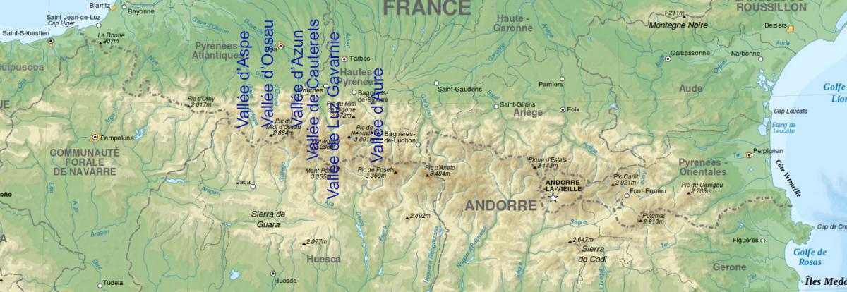
The Pyrenees National Park is full of beautiful hikes, each one more beautiful than the next. The purpose of each of these hikes is often a lake, but the landscapes leading to it are often prettier than the lake itself. This mountain range consists of several steep valleys. We fell in love with the Aspe Valley, which we think is a little more "wild" than the Ossau, Cauterets and Luz Gavarnie Valleys.
Advice : before going on a hike, check the weather forecast because it can change quickly in the mountains. Bring warm clothing.

Luz Gavarnie Valley : Breach of Roland
![]()
 3,20 miles to the refuge
1312 feet of elevation gain
![]() 3 to 4 hours
3 to 4 hours
to the refuge
![]()
Free
Hike up to the Breach of Roland Refuge (or Sarradets Refuge). From the parking lot, you must first reach the Port of Boucharo and then turn left at the foot of the mountain. The ascent is regular until you have to cross the waterfall (ice melting). Here, it climbs rough and the rocks can be slippery. From there, you can admire the false breach. When you arrive at the refuge, you have a view on the Cirque of Gavarnie and the Breach of Roland. Count 6,5 miles round trip with a difference in altitude of 1312 feet.
You can then reach the foot of the Breach of Roland by continuing after the refuge: 0,27 mile more but especially 442 feet of difference in altitude.
If the view is already beautiful from the refuge, being at the foot of the Breach is magnificent. The small glacial lake with its turquoise waters offers a splendid panorama.
Access : after Gavarnie, go to the parking lot of the Col de Tentes.
Luz Gavarnie Valley : Bellevue Plateau
![]()
 1,9 miles one way
1181 feet of elevation gain
![]() 2 to 3 hours
2 to 3 hours
![]()
Fee parking
The hike follows an old mule track in the forest then steep laces before arriving at the Bellevue plateau and its meadows. It is beautiful, quiet, ideal for picnicking with a view of the Cirque de Gavarnie. This walk is 3,7 miles round trip and 1181 feet of difference in altitude if you go down the same path.
Otherwise, you can go back down to the Cirque de Gavarnie. The path descends quietly, passes near a waterfall before reaching a beautiful green meadow and its river. Continuing to the right, you arrive at the Hotellerie of Cirque of Gavarnie. The climb up the meadow to the hotel is steep. Count 2,8 miles from the Bellevue Plateau to the Hotellerie of Cirque and 508 feet of difference in altitude. The return is by the classic Cirque path over 2,7 miles.
Access : from the village of Gavarnie.
Gavarnie Valley : Cirque of Gavarnie
![]()
 3 miles one way
1237 feet of elevation gain
![]() 3 to 4 hours
3 to 4 hours
![]()
Fee parking
Very touristic hiking in the summer, which allows to see a very high waterfall. 10 kms round trip from the village of Gavarnie with 377 metres of elevation gain to the foot of the waterfall.
Access : from the village of Gavarnie.
Copyright Magali and David BELLEC