In this page, you will find informations and advices we can give, based on our experience
Pyrenees National Park
- Aspe Valley -
What to do if you have little time : Aspe Valley
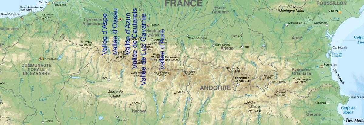
The Pyrenees National Park is full of beautiful hikes, each one more beautiful than the next. The purpose of each of these hikes is often a lake, but the landscapes leading to it are often prettier than the lake itself. This mountain range consists of several steep valleys. We fell in love with the Aspe Valley, which we think is a little more "wild" than the Ossau, Cauterets and Luz Gavarnie Valleys.
Advice : before going on a hike, check the weather forecast because it can change quickly in the mountains. Bring warm clothing.

Aspe Valley : Montagnon Lake
![]()
 5,7 kms one way - 1 055 metres of altitude difference - 4h00
![]() 1 day
1 day
![]()
Free
Difficult hike of 11.4 kms round trip to the viewpoint above Montagnon Lake for a total altitude difference of 1,055 metres. From the beginning, it climbs steeply in the undergrowth, then the slope softens as it leaves the woods to the Cure-det-Cam cabin. Arriving at this hut, you will have covered 2.4 kms and 500 metres of altitude difference. Then continue for 1.3 kms (230 meters of altitude difference) until you reach a fence (Taillandere Pass). Turn right along this fence and towards a stone. This last climb up into the gravel is quite difficult but the descent is even more difficult. Once this last difficulty is over, you will be at Montagnon Lake. You can continue by going around the lake from the left to the Montagnon d'Iseye to have a bird's eye view of the lake and admire its heart shape. This climb represents an additional effort of 700 meters for 150 meters of altitude difference but it is worth it. A big favorite.
Access : go to the village of Aydius, take the Salars de Bas road and then Salars de Haut. Continue on Sartiat and turn right at GPS point N42°59'45.1" W0°30'13.9". Park at GPS point N42°59'41.4" W0°30'26.1".
Aspe Valley : Ansabere
![]()
 3,4 kms one way minimum - 1h20
![]() 1 day
1 day
![]()
Free
This hike, very beautiful and pleasant, has several destinations:
- Ansabere's huts : from there, you have a superb view of the Aiguilles d'Ansabere. From the Lamary Bridge (2nd car park), it is necessary to count 3.4 kms one way, about 1h20 and 423 meters of positive altitude difference.
- Lake Ansabere : 50 minutes of climbing
- the peaks : from the huts, it is still necessary to climb 3 kms with a positive difference in altitude of 518 meters. But it is worth it for the view of Ansabere Lake as well as a view on the Spanish side also of a lake.
In total, this hike is 17.5 kms round trip with a difference in altitude of 1,105 metres.
Access : from Lescun, drive 7 kms southwest. There are 2 car parks. The 1st is Massousa and the 2nd is Pont Lamary at 2.3 kms by foot (35 min and 210 meters of positive altitude difference).
Aspe Valley : Estaens Lake
![]()
 3,7 kms one way - 1h30
![]() 3 to 4 hours
3 to 4 hours
![]()
Free
Estaens Lake is located in Spain just on the border with France. The hike that leads to it is about 7 kms round trip for 450 meters of altitude difference. At the beginning of the path, you will pass at the foot of the Espelunguere waterfall, which is quite beautiful. Then the trail continues in the undergrowth for a very steep climb. At the end, there will be iron ladders to climb. The lake is very beautiful.
Access : from Estaing, park at the car park of the Estaens hydroelectric power plant, accessible via a rocky track.
Aspe Valley : Sanchese Plateau
![]()
 2 kms one way
![]() 3 to 4 hours
3 to 4 hours
![]()
Free
Sanchese is a green plateau where a river flows. At the end of it falls a waterfall. It is a nice and refreshing place for a picnic or to rest after a hike. From the car park, there is a small climb on foot and then you will pass through an undergrowth before arriving on the plateau. From the car park to the waterfall, it takes 5.5 kms round trip.
Access : From Lescun, park at the Anapia car park.
Aspe Valley : the Path of Mature
![]()
 Depending on wish
![]() Depending on wish
Depending on wish
![]()
Free
The Path of Mature is a cornice carved into the rock of a cliff and overlooking a steep valley : the Gorges d'Enfer. Opposite, you will see the Fort du Portalet. Drive at least 500 metres to reach a "bend" to the right that allows you to observe the vertical wall under this cornice (at GPS point: N42°53' 15.9" W0°33' 33.8").
Access : from Lescun, take the N134 south to Fort de Portalet.
Copyright Magali and David BELLEC