![]()
![]()
![]()
![]()

In this page, you will find informations and advices we can give, based on our experience
Ojito Wilderness - New Mexico
What to do if you have little time : The journey to get there can be long, so if you have little time you won't go to Ah Shi Sle Pah.
Ojito Wilderness s managed by the BLM. It therefore has no facilities, apart from some car parks. It's quite large and renowned for mountain bikers. On the track there is a first car park from which many trails for biking start. We ventured further down the track named Cabezon Road to see some hoodoos. If Ojito Wilderness is extended, the hoodoos area is more localized and hoodoos are ultimately not very numerous. The color (yellow) is however quite different from those that can be seen in Utah like Toadstool hoodoos (red) or Wahweap hodoos (white). Here you will also see a small yellow "wave". It's pretty nice, but there's not much else to see.
Ojito Wilderness
![]()
 1 mile one way
![]() 1 to 2 hours
1 to 2 hours
![]()
Free

GPS tracks to download
![]()
GPS tracks to download
From the parking area, walk back East about 400 feet. A trailhead leads north into the wilderness on the opposite side of the road from the parking. This trail is easy and only 2 miles roundtrip (GPS for the yellow hoodoo : N35°30'06.8" W106°55'26.7").
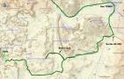
Access : from Bernalillo, travel North on U.S. 550 for about 21 miles. Turn left onto Cabezon Road (County Road 906). At the fork turn left for approximately 9¼ miles to a Ojito Wilderness sign. Continue almost 1¾ mile to a developed parking area on the left side of the road. From the parking area, walk back about 400 feet to the east where a trail leads north into the Wilderness on the opposite side of the road.
.jpg)
.jpg)
.jpg)
.jpg)
.jpg)
.jpg)
.jpg)
.jpg)
To see around
Lodging
There are many motels in Albuquerque and Bernalillo. We have tested :
Copyright Magali and David BELLEC